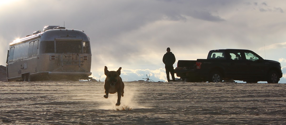
We spent two nights near Lassen Volcanic in early October 2022 as part of Big Trip #4.

We had originally booked three nights for our Lassen Volcanic stop, but after being underwhelmed by our first hike, we decided to leave a day early. No offense, Lassen. It’s hard to compete with the other national parks in the neighborhood. We still managed to cram a good bit of exploring into a short time and felt like we at least got a reasonable overview of Lassen Volcanic.

We didn’t know much about Lassen Volcanic before planning this trip; here’s what we learned along the way. The park is known for its namesake peak, areas of hydrothermal activity, and it has several lakes for non-powered boating and cold-water swimming. The majority of visitors will access the park from the northwest entrance, near Manzanita Lake, where most of the park’s amenities are located. A 30-mile highway connects the northwest and southwest entrances with some scenic overlooks and historical and geological points of interest along the way. The northeast, southeast, and south entrances to the park are much more remote, and we didn’t consider visiting those sections.
In 2021, over the course of several months, the largest single fire in California history spread across almost one million acres, affecting 69% of Lassen Volcanic. You can see the scars from the Dixie Fire along the scenic highway through the park and on some trails, and it’s pretty jarring.
Campground
The national park has three RV-friendly (but without hookups) campgrounds: Manzanita Lake, Butte Lake, and Summit Lake campgrounds. Of those, only the largest, Manzanita Lake, can handle a 28′ travel trailer. Once again, however, we opted to reserve a campsite outside the park so that we’d have power, in case of freezing weather–and we also liked the idea of taking Bugsy to the beer garden in tiny Shingletown. In retrospect, we should have stayed in the park and maximized our time there, as Shingletown was a dud.

We stayed at Shingletown KOA, a very nice campground only fifteen minutes west of the national park entrance. Our campsite had a big pile of dog doo in it when we arrived, but after we dealt with that, we were very happy there. The spot next door was suuuuper close, so we were very happy it remained vacant.

The campground has a huge wooded area in the back partially for tent camping and partially for walking, bird watching, and entertaining your bored dog. This big woodsy section is the reason we were very happy with this KOA.

The tiny town of Shingletown is a few minutes down the road, and our first evening in town we drove into town with Bugsy to get a beer at Pioneer Hillside Pizza‘s beer garden. Surprise–they don’t allow dogs in their beer garden. What a disappointment. Shingletown has a gas station, small grocery, an ice cream shop, and a gift store, but not a dog-friendly beer garden. Redding, 30 minutes west, has a lot more going on if you need city conveniences.
Hiking
We knew we wanted to climb Lassen Peak, and otherwise we relied on the internet and the park brochure to choose a couple others. As is the case in most US national parks, dogs aren’t allowed on the trails in Lassen Volcanic.
Lassen Peak

Lassen Peak is one of the world’s largest lava dome volcanoes, and it’s the southernmost active volcano in the Cascades. It last erupted in 1917 and is currently dormant, but the magma chamber below is active and so the volcano could erupt again.

The hike is a steep 5-mile out-and-back with a bit of a rock scramble at the end–and some snow at the summit! The views along the trail were fantastic, and while it wasn’t crowded when we started at 9am, it was getting very busy as we came back down from the peak. If you can handle a moderately tough 2.5-mile climb up a mountain without shade, this hike is a must-do in Lassen Volcanic. The trailhead is a 35-minute drive down the scenic highway past the Manzanita Lake area.
Chaos Crags

We chose the Chaos Crags hike from AllTrails based on its super ratings, the length (4 miles), and its proximity to Manzanita Lake. We wanted to get in a few miles on the afternoon we arrived and it seemed like a good fit. The hike winds through a pleasant forest, up to Chaos Jumbles, a debris field from a rock avalanche 300 years ago, and to the base of Chaos Crags, the youngest group of lava domes in the national park, with a seasonal lake.

Our opinion was: it was nice enough, but… meh. There weren’t really views along the trail, and the lake at the end was dry (it usually dries up by the end of August)… It was on this hike that we started talking about shortening our stay by one day, because if this hike had such crazy-high ratings, maybe this wasn’t the national park for us. The next day Lassen Peak completely redeemed the park in our eyes, but we still felt ready to move on.
Manzanita Lake Trail

Manzanita Lake Trail was on our list for the pretty reflections of Lassen Peak and Chaos Crags in the water. It’s a short (1.7 miles) and flat stroll through lovely woods along the water, and we saw mule deer, buffleheads, Canada geese, ground squirrels, chipmunks, Douglas squirrels, and Stellar’s jays (I love them).
Burney Falls

Outside the national park, we stopped at McArthur-Burney Falls Memorial State Park on the way to Shingletown KOA from Crater Lake. From the Manzanita Lake area of Lassen Volcanic, it’s a 45-minute drive, but if you’re a waterfall lover, the 129ft Burney Falls is worth the trip. We had no trouble parking the Airstream in the RV parking lot (remember, this was in October! In the summer the park is often completely full!) and hiking 1.5 miles or so up to the falls. If you don’t have a trailer attached to your vehicle, like a normal person, you can park close to the falls.

There’s an RV campground in the state park; to dodge the crowds, it would be smart to stay overnight and hike around first thing in the morning. Note that dogs are only allowed on some trails in the park. You’ll pass the railroad trestle from the movie Stand By Me on the way to the state park if you’re driving down Rt 89 from the north–here’s where it is!
To do
Other hikes on our to-do list were: Kings Creek Falls, a 2.3-mile loop to 30-foot falls featured on the park map; Brokeoff Mountain, a tough 7.6-mile hike with panoramic views from the top, but it’s an hour’s drive from our campground; and Bumpass Hell, a very popular and easy 3-mile hike partially on a boardwalk through the park’s largest hydrothermal area. Outside the national park, Subway Cave is a 1/3-mile long cave in Lassen National Forest a half-hour from the KOA. It’s on the way to Burney Falls, and had we known about it when we drove past it, we would have stopped. The only dog-friendly hikes we could find were in Redding, 30 minutes away, and they weren’t that compelling.

Onward to meet up with friends at Lake Tahoe!


Leave a Reply